


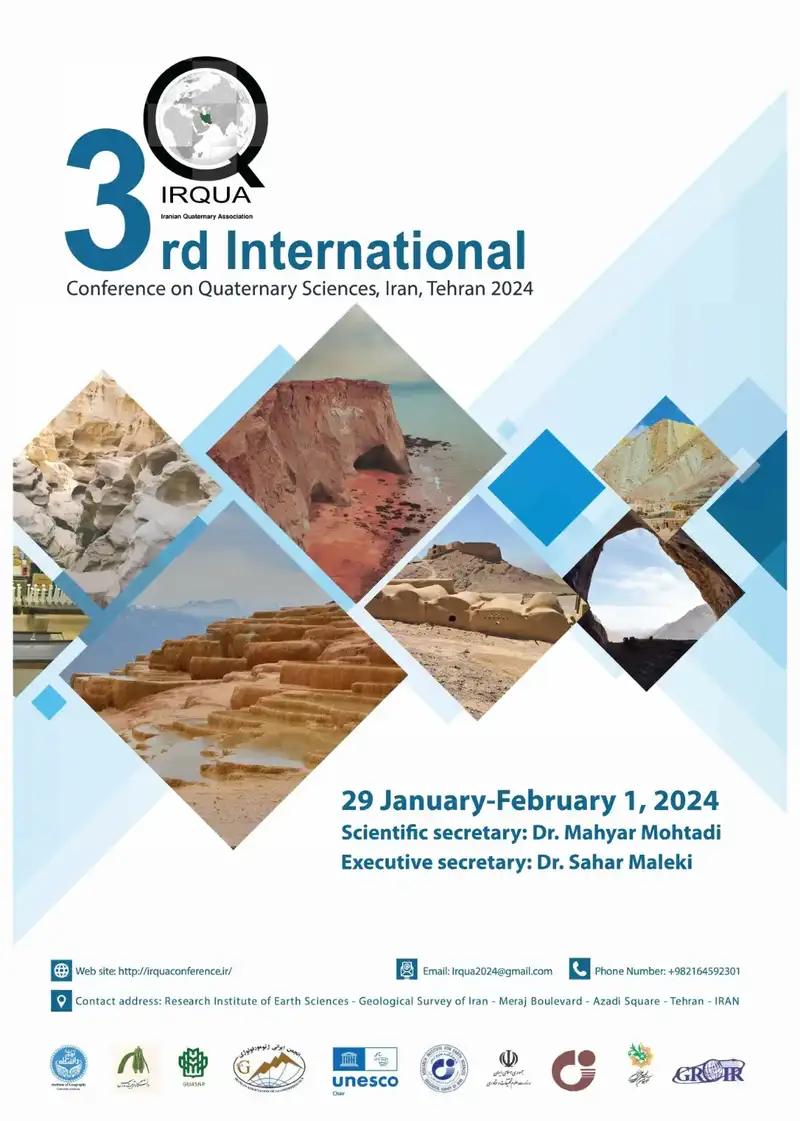
3rd International Conference and 6th National Conference of Quaternary Sciences – Quaternary Society of Iran
Important Dates
- *January29-February1,2024: Conference
- *May1,2023: Registration opens, call for the abstracts
- *November1,2023: Deadline for abstract submission
- *December1,2023: Announcement of abstracts
Aims
Quaternary sciences play a critical role in contributing the necessary knowledge to face current societal challenges and to mitigate the ongoing climate change. To this end, the IRQUA aims to convene the Iranian and international Quaternary scientists to present their work and discuss the processes and mechanisms that shaped the landscape, environments, civilizations and ecosystems of the past 2.5 million years.
The IRQUA aims to exchange research interests on global and regional scale and promote interdisciplinary studies in Quaternary science. The meeting will consist of various interconnected sessions covering paleoclimate and paleoceanography, geomorphology, soil system sciences, natural hazards, stratigraphy, sedimentology and paleontology, and archeology.
The meeting will foster greater collaborations to lead to solutions in all fields of Quaternary science, and to share and engage the science community, policymakers and stakeholders. We hope to see you in this meeting of action and collaboration.
Mahyar Mohtadi, PhD
Scientific Secretary
اهداف
علوم کواترنر نقش مهمی در کمک به دانش لازم برای رویارویی با چالشهای اجتماعی فعلی و کاهش تغییرات آب و هوایی جاری دارد. به همین منظور، IRQUA قصد دارد دانشمندان ایرانی و بینالمللی کواترنر را برای ارائه کار خود و بحث در مورد فرآیندها و مکانیسمهایی که چشمانداز، محیطها، تمدنها و اکوسیستمهای 2.5 میلیون سال گذشته را شکل دادهاند، گرد هم آورد.
هدف IRQUA تبادل علایق تحقیقاتی در مقیاس جهانی و منطقه ای و ترویج مطالعات بین رشته ای در علوم کواترنر است. این نشست شامل جلسات مختلف بهم پیوسته ای خواهد بود که اقلیم دیرینه و دیرین اقیانوس شناسی، ژئومورفولوژی، علوم سیستم خاک، مخاطرات طبیعی، چینه شناسی، رسوب شناسی و دیرینه شناسی و باستان شناسی را پوشش می دهد.
این نشست همکاریهای بیشتری را برای راهحلهایی در تمام زمینههای علوم کواترنر، و به اشتراک گذاشتن و مشارکت جامعه علمی، سیاستگذاران و ذینفعان تقویت خواهد کرد. امیدواریم شما را در این جلسه اقدام و همکاری ببینیم.
Subjects
Climate records and models
All contributions related to paleoclimatic and paleogeographic changes in marine and terrestrial systems, abrupt and long-term climate change, historical and future climate, the use and development of (novel) climate proxies, simulations of past and future climate
Human evolution and ancient civilizations
All contributions related to anthropology, archeology, ancient civilizations, population dynamics and behavioral variability, cultural diversity, human-environment interaction, cultural-climatic evolution, vegetation, land-use and human impact
Landforms and soil system sciences
All contributions related to fluvial, estuarine and coastal geomorphology, lake- and sea-level changes, soil biology, chemistry and physics, soil and environment interaction, soil formation, diagenesis, erosion and transport, loess and paleosols
Natural Processes and Geohazards
All contributions related to extreme weather and climate events, drought, fire and water scarcity, floods and landslides, earthquakes and neotectonics, volcanic hazards and aerosols, pollution, risk assessments and -reduction
Geochronology, stratigraphy and sedimentology
All contributions related to application of, and advances in, geo- and thermochronology, paleomagnetism and magnetostratigraphy, radionuclides, radiocarbon and luminescence dating, trace and stable isotope geochemistry, correlations and mapping, statistical methods, scales and scaling, eolian dust and sedimentation, carbonate and siliclastic sediments, modern and ancient sedimentary environment
محورها:
سوابق و مدل های آب و هوا
همه مشارکتهای مربوط به تغییرات دیرینهاقلیمی و جغرافیایی دیرینه در سیستمهای دریایی و زمینی، تغییرات ناگهانی و بلندمدت آب و هوا، آبوهوای تاریخی و آینده، استفاده و توسعه پراکسیهای آب و هوایی (جدید)، شبیهسازی آب و هوای گذشته و آینده
تکامل انسان و تمدن های باستانی
همه مشارکت های مربوط به مردم شناسی، باستان شناسی، تمدن های باستانی، پویایی جمعیت و تنوع رفتاری، تنوع فرهنگی، تعامل انسان و محیط، تکامل فرهنگی-اقلیمی، پوشش گیاهی، کاربری زمین و تاثیرات انسانی
لندفرم ها و علوم سیستم خاک
همه مشارکتهای مربوط به ژئومورفولوژی رودخانهها، مصبها و ساحلی، تغییرات سطح دریاچه و دریا، زیستشناسی خاک، شیمی و فیزیک، تعامل خاک و محیط، تشکیل خاک، دیاژنز، فرسایش و حملونقل، لس و پالئوسولها
فرآیندهای طبیعی و مخاطرات زمین
همه مشارکتهای مربوط به رویدادهای آب و هوایی شدید، خشکسالی، آتشسوزی و کمبود آب، سیل و رانش زمین، زلزله و نئوتکتونیکی، خطرات آتشفشانی و ذرات معلق در هوا، آلودگی، ارزیابی خطر و کاهش
زمین شناسی، چینه شناسی و رسوب شناسی
همه مشارکتهای مربوط به کاربرد و پیشرفتها در زمینشناسی و گرماشناسی، دیرینهمغناطیس و چینهنگاری مغناطیسی، رادیونوکلئیدها، تاریخگذاری رادیوکربن و لومینسانس، ژئوشیمی ایزوتوپهای ردیابی و پایدار، همبستگیها و نقشهبرداری، روشهای آماری، مقیاسها و پوستهگذاری، گرد و غبار و پوستهبندی بادیوم. و رسوبات سیلیسی، محیط رسوبی مدرن و باستانی
Registration and Excursion fee
Participation is both in-person and virtual. We look forward to seeing you in Tehran or online.
*Conference fees: Lunch, conference package, icebreaker.
*Excursion fees: Lunch, dinner, excursion package, bus and breaks
*Foreign participants will be charged in cash in Iran.
Excursion 1
Alborz Mountains and Central Plateau
Excursion 2
Makran Region
| Categories | Conference (2 days) | Excursion 1 (2 days) | Excursion 2 (5 days) |
| Abstract submission | Free | – | – |
| Online participants | Free | – | – |
| Members of the Iranian Quaternary Association | USD 50 | USD 100 | USD 200 |
| Non-members of the Iranian Quaternary Association | USD 100 | USD 100 | USD 200 |
| Students & accompanying persons | USD 50 | USD 100 | USD 200 |
*Hotel expenses are the responsibility of the participants. If you need to coordinate, please contact the executive team.
*The list of hotels is below. If you need guidance and coordination, please contact the executive team.
1- Espinas hotel *****
2- Olympic hotel ****
3- Pazhouhesh hotel ***
Alborz Mountains and Central Plateau
Badab-e Surt colorful spring in Sari, Cheshmeh Ali spring as a part of Damghan fault (length 100 km) close to Teppe Hesar site (4000 BC) and Haj Aligoli desert (Figure 1) combination of Sand dunes, Nebkha deposits, and salt playa.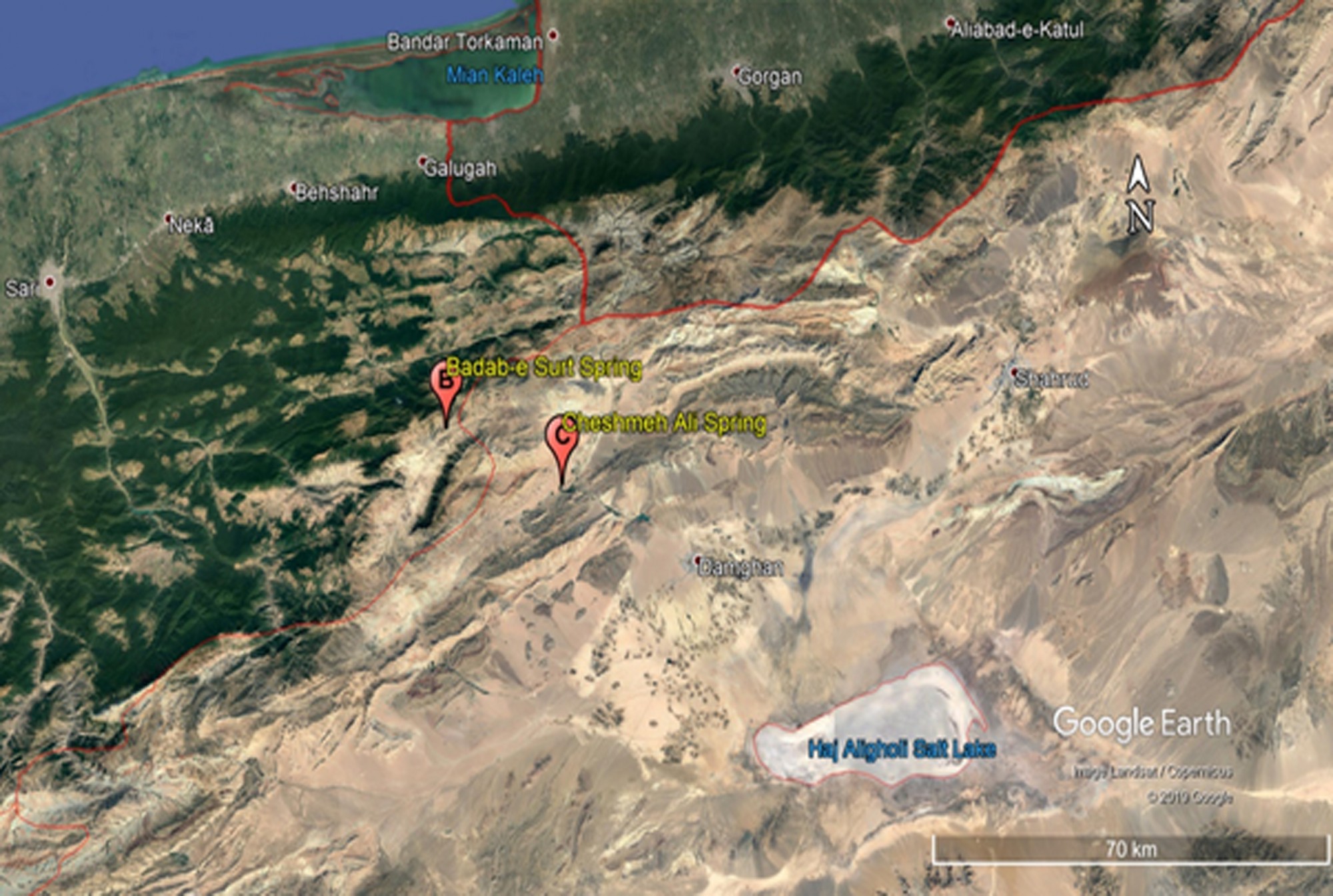
Figure 1: Satellite view of Haj Aligholo Playa, Cheshmeh Ali and Badab-e surt springs
Badab-e Surt spring
Badab-e Surt spring (BSs) lying at about 1,841 m asl in Alborz Mountain ranges is located in Northern Iran (Mazandaran province), 100km of Southern Sari city and east of Orost village, it is recognized as a World Heritage Site. A few other places in the world resemble it, including the Pamukkale in Denizli in southwestern Turkey, Mammoth Hot Springs in the USA, and Huanglong in Sichuan Province of China (Sotohian and Ranjbaran 2015). Geologically the spring comes from Shemshak Formation a thick sequence of siliciclastic sediments and coal-bearing deposits.
BSs (Figure 2) is including two springs, one with the saline and the other spring water has a sour taste and orange color. They formed during Pleistocene and Pliocene, by the time the discharged cool bicarbonate-rich waters from these springs has resulted in the formation of red, orange and yellow travertine terraces with crystalline crust, pisoid, tufa, and carbonate black muds lithofacies (Sotohian and Ranjbaran 2015).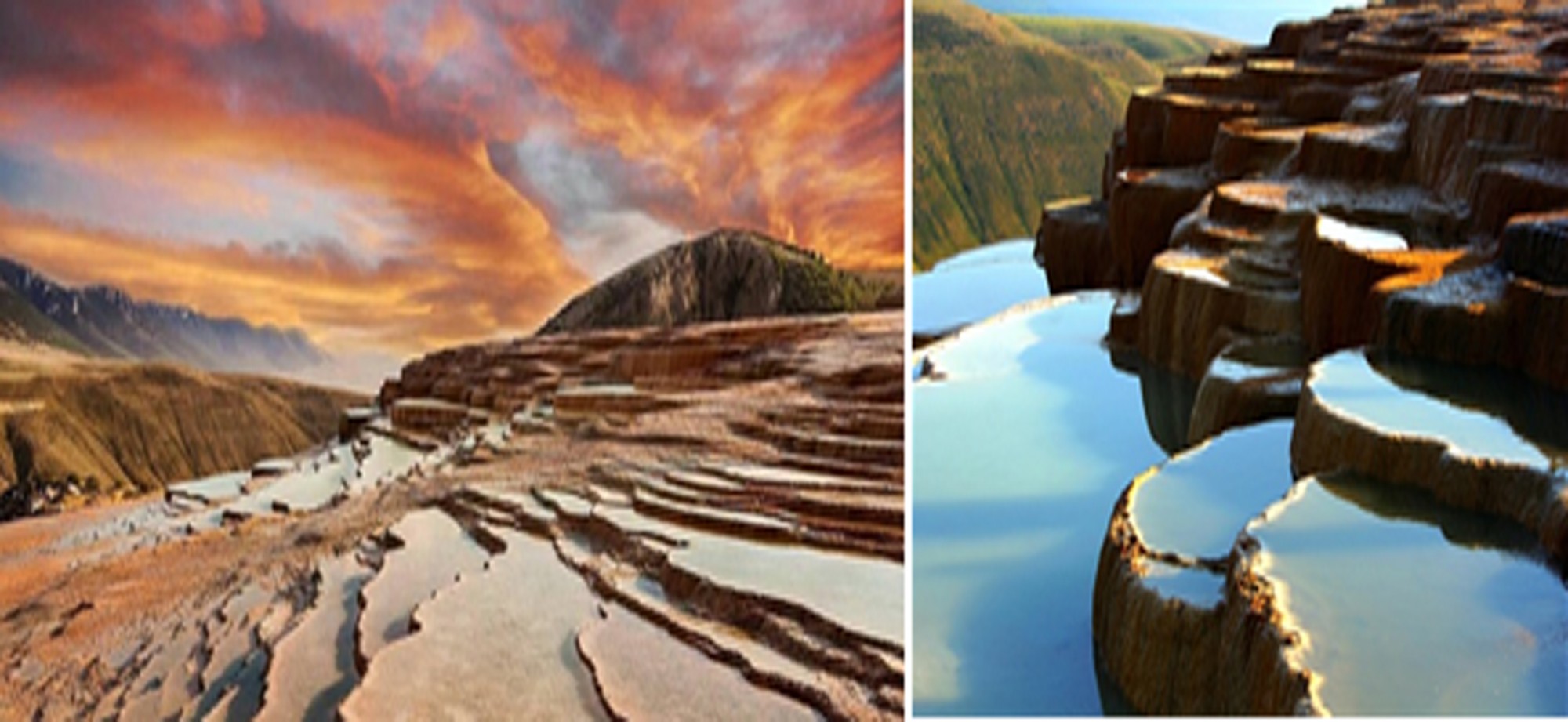
Figure 2. Badab-e Surt Spring
Haj Aligoli desert
Haj Aligoli /Chah-e-jam/Damgan desert is located at about 1050-1094 m asl in the southern Alborz Mountains close to dry plains of Iran central plateau and southeast of Damgan city (Semnan province). The desert area is 2391 sq.km; average temperature during summer season (JJ) is 48 ⁰C and -5 ⁰C in winter (JF) (Vahdati Nasab and Hashemi 2016). Damgan desert is a sedimentary-structural phenomenon (Ahmadi 1999).
Due to poor vegetation, negative effective precipitation, and wind activity desert landforms Nebkah, Barkhan, Seif, and Sand dunes are dominant in the area (Vali and Musavi 2010). Based on sedimentology Damgan desert can be divided into three parts. The first part, which comprises 47% of the desert, is the flat plate of clayey sediments, the second part is the wet or swampy area, which covers an area of about 34% of the surface of the desert, and finally the remained central part is a salt desert (Figure 3) (Krinsley 1970). Discovered Upper/Epipaleolithic periods settlement evidence in the area indicating that climate during the Late Pleistocene was different from that present (Vahdati Nasab and Hashemi 2016).
Figure 3: Damgan Salt Playa
Cheshmeh Ali spring
The biggest karstic spring in Semnan province called Cheshme-Ali (CAs)(Figure 4) is located at 30 km of NW Damghan and is one of Damghan’s desert catchments. CAs water discharge is 500-700 l/s and which provides drinking water for part of Semnan city and 25 nearby villages. The average annual precipitation of the CAs watershed is 155 whereas the number for the evaporation is 1900 mm. Geologically CAs are a part of the eastern Alborz zone which is a combination of the thick Delichae and thin Lar calcareous formations (Hosseini et al. 2018).
Figure 4: Cheshmeh Ali and the constructed palace
Excursion 2
Makran- Chabahar
In geology studies, Iran’s East area is usually surveyed as an independent unit. This area was isolated from the sea in the late of third geological era because of organic movements and Lime scale build of marine that type are stacked in it at first and then sediments with relatively coarse and fine materials are stacked in it. The southern part of the province (Makran) is one of the areas that is under the gradual subsidence because of large thickness of sandy clay sediments that its depth reaches to 1 Km.
Accordingly, the Indian Ocean’s crust slope into the ground under this area that is one of the causes for creating a lot of mineral water springs and mud volcanoes in this area. Heights of Sistan and Baluchistan belonged to the second and third periods of geology and its stones are often Lime and plaster. According to the geologists, some mountains of this province (like Taftan volcano) belong to the late third era and early fourth era. Width of the province’s mountains is increased from the north to the south and reaches to its maximum amount between Iranshahr-Koohak (Bootorab, 2006).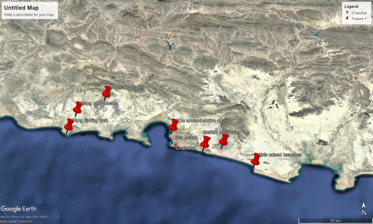
Figure 1: Satellite view of places to visit in Makran-Chabahar
-Mud Volcanoes
One of the unique Iran’s geomorphology phenomena that are mainly located in the south of Sistan and Baluchistan province is mud volcanoes. These effects are cone-like shapes similar to volcano that instead of lava, flower according with hydrocarbon gases (like Methane), di oxide carbon and petroleum materials exit from its crater (Yazdi et al., 2012).
According to the existence of substrates in the flower of mud volcanoes, today flower therapy has a special status and a lot of physicians find its effectiveness. Besides tourism, mud volcanoes are important in the field of treatment and can be useful in treating diseases of muscle, skin, gastrointestinal etc. (Yazdi et al., 2012). Baluchistan mud volcanoes are young and their existence backed from 30 to 40 thousands years ago (Negaresh, 2001). Mud volcanoes of this area are about 13 ones and their most important ones are Pirgel, Napag, Ain, Tang and Balbolok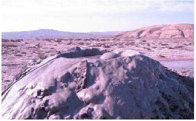
Figure 2: Napag mud volcano crater (Yazdi et al., 2016)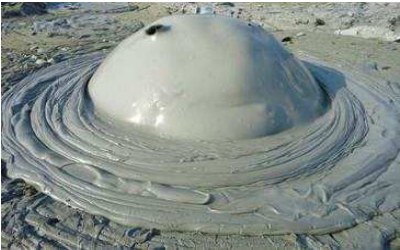
Figure 3: Created bubble in outgoing flowers of Tang mud volcano
-Hara Jungle (Mangro)
Hara trees are expanded in Oman coasts especially around Gowatr, Khoors and Bahookalat
estuaries. The name of its kind is Avicenia Marina that their height reaches from 6 to 9 m. The leaves of these trees act as refinery and pass the salts (Negaresh, 2005). These trees grow mainly on fine sediment of the coast, estuaries and coastal marshes that are influenced by tidal currents (Momeni, 1991). Hara jungles with sea lanes between them create beautiful landscapes.
Figure 4: Hara Jungle (Mangro)
-Wetlands (The Pink Lagoon)
Lipar or the Pink Lagoon is a 13 kilometer wetland located 5 kilometers from Chabahar on the road to Gwatre. In late winter and early spring as well as end of summer and early fall visitors can witness the red tide phenomenon at this wetland. Lipar Wetland is a great bird watching destination and is home to the coot, flamingo, grebe, great egret, grey heron, purple swamphen, sandgrouse, see-see partridge, grey francolin, tawny eagle, Eurasian teal and kestrel.
Lipar wetland is also home to the endangered marbled duck. Lipar is the shores of beautiful and interesting areas of the region. Lipar wetland near the village of Ramin and 15 km East Coast Chabahar on the road Chabahar – Gwatre with the prospect of was fantastic. Growth of oak and nettle in the water of beauty has created a wonderful scene that cannot be seen anywhere else in the country. Lipar Red lagoon waters red with a beautiful view is taken.

Figure 5: Lipar Wetland or the Pink Lagoon
-Miniature Mountains (Mars or Martian Mounts)
25 kilometers of Chabahar on the northern coast of Oman Sea (Chabahar road-Gwatre), water and wind erosion on the marl- sandstone formations green area, the beautiful scenery of the foothills regular and frequent bad as the land under canvas (Bad Land) or the Mars mountains or the miniature mountains are established. These mountains are extremely beautiful and considered to be symbols of the unique geo-morphological phenomena of Chabahar. Mars or miniature mountains have been extensive parallel to the sea (along east – west) from near Kachoo village to the Gwatre Bay.
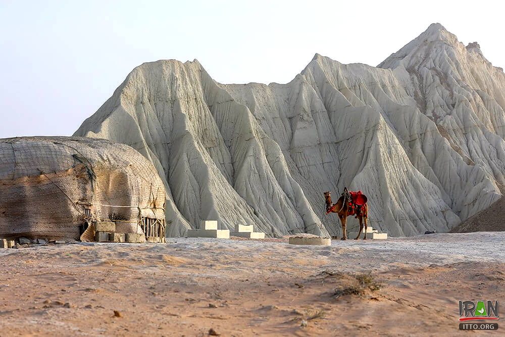
Figure 6: Mars or Miniature Mountain (https://itto.org)
-Erosion of honeycomb (Sadaf)
Wind erosion and surface water, especially rain in southern coasts of Chabahar, beautiful buildings and fungal forms honeycomb has established that locals say they Sadaf. These beautiful shapes in sandstone and carbonate rocks can be seen in abundance.

Figure 7: Erosion of honeycomb (Sadaf) on the road Lipar – Chabahar (Yazdi, et al, 2016)
برای اطلاعات بیشتر و ثبت نام به سایت همایش مراجعه نمایید.


نظرات کاربران